
As a potent weather system brews over the waters of the Bay of Bengal, international meteorological eyes are locked on its evolution into a potential cyclonic storm expected to be named Arnab.
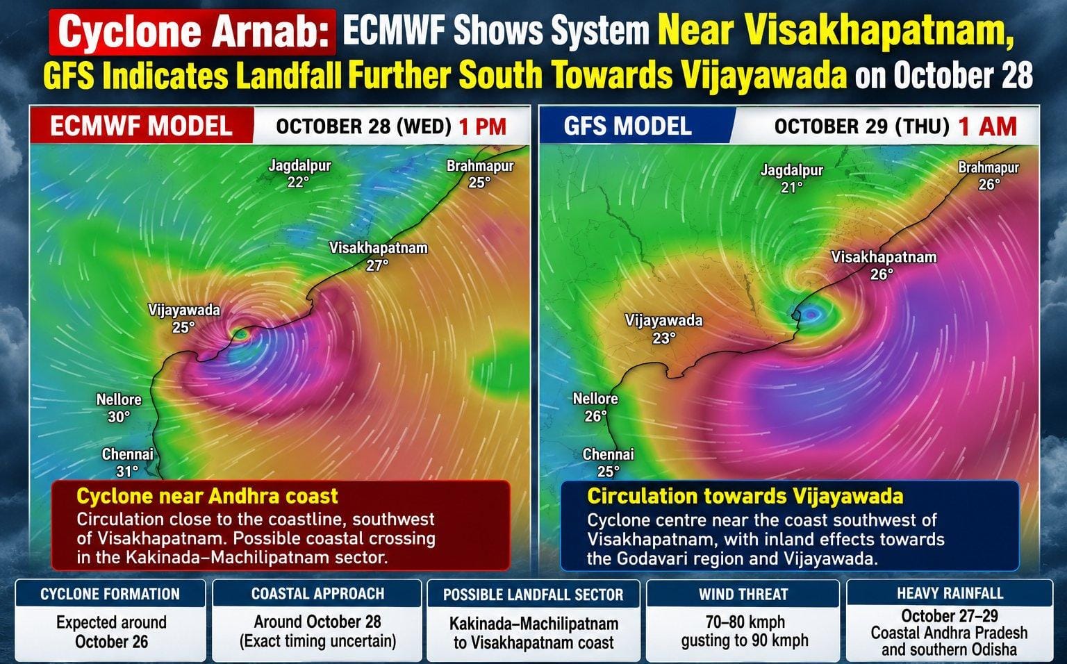
Recent high-resolution visualisations from leading global weather prediction engines—Europe’s ECMWF and America’s GFS—have painted a tense picture for the eastern coastline of India, highlighting an impending landfall around October 28.
However, while both models agree on the development of a severe system, they diverge significantly on the exact landfall coordinates, timing, and inland reach, leaving authorities tracking a tense corridor stretching from Visakhapatnam down to the Krishna–Godavari delta.
ECMWF Projections: A Mid-Sector Coastal Crossing
According to the European Centre for Medium-Range Weather Forecasts (ECMWF) model simulation mapped for 1:00 PM on October 28, the developing cyclonic circulation tightens aggressively as it approaches the Andhra Pradesh coastline just southwest of Visakhapatnam.
-
Key Characteristics: The visual data portrays a compact, highly energetic core wrapped in intense gale-force bands over the west-central Bay of Bengal.
-
Predicted Impact Zone: The ECMWF projection points towards a sharp coastal crossing situated in the broader Kakinada–Machilipatnam sector, threatening heavy downpours, squally winds, and rough surf across central coastal districts.
GFS Projections: A Southerly Slide Toward Vijayawada
In contrast, the Global Forecast System (GFS) run by the United States points to a slightly delayed and more southerly trajectory. The GFS visualisation for 1:00 AM on October 29 plots the system’s centre closing in on the coast southwest of Visakhapatnam but extending its ferocious wind fields deeper south and inland.
-
Key Characteristics: The American model illustrates a broader, more expansive wind shield spanning across wide sections of the sea and coastal terrain.
-
Predicted Impact Zone: Due to the extended outer bands, the GFS model indicates that deep inland zones toward the Godavari region and Vijayawada could experience severe gusty conditions and torrential rains hours after the initial coastal brush.
Regional Preparations and Southern Odisha Alert
Beyond Andhra Pradesh, the vast circulation of the prospective system places southern Odisha squarely within the broader hazard cone, threatening enhanced rainfall, localised waterlogging, and choppy marine conditions. Local disaster management authorities and meteorological departments have urged fishermen to stay off open waters, while district administrations review evacuation blueprints and low-lying drainage systems.
With weather models continuing to fine-tune their runs ahead of the crucial window, residents across the vulnerable coastline are advised to monitor official updates closely as Cyclone Arnab shapes up to be a major weather event for India’s east coast.