

The India Meteorological Department has flagged a developing weather system over the Bay of Bengal that could bring increasingly rough seas and strong winds over the next few days, with potential rainfall impacts for parts of Odisha later in the week.
According to the Evening Weather Bulletin issued by the Meteorological Centre, Bhubaneswar, on 22 October 2026, an upper air cyclonic circulation over the southeast and adjoining eastcentral Bay of Bengal and Andaman Islands is expected to move west-northwestwards. Under its influence, a low-pressure area is very likely to form over the southeast and adjoining east-central Bay of Bengal around 23 October. The system is then expected to continue moving west-northwestwards and intensify further.
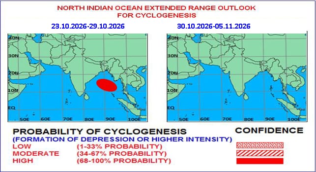
An extended-range outlook accompanying the bulletin indicates a high probability of cyclogenesis — the formation of a depression or higher-intensity system — over the Bay of Bengal during 23–29 October. The system is expected to intensify into a depression around the morning of 25 October and strengthen further over the following days.
Adverse Weather Expected Over the Bay
IMD has outlined a progressive deterioration in weather conditions over the Bay of Bengal:
- Squally weather with winds of 35–45 kmph gusting to 55 kmph is very likely over the eastcentral and adjoining southeast Bay of Bengal from the evening of 23 October.
- Winds are expected to strengthen to 45–55 kmph gusting to 65 kmph by the evening of 24 October, and further to 50–60 kmph gusting to 70 kmph by the evening of 25 October over the eastcentral, adjoining westcentral and southeast Bay.
- Gale-force winds exceeding 70–80 kmph gusting to 90 kmph are likely over the westcentral and adjoining eastcentral Bay of Bengal from 26 October, with further intensification possible as the system moves west-northwestwards through 28 October.
Sea conditions are forecast to turn moderate to rough from the evening of 23 October, becoming rough to very rough from 24 October onwards over the central and adjoining southeast Bay. Conditions are expected to become very rough over the central Bay from 25 October evening and high to very high from 26 October morning through 28 October over the westcentral and adjoining eastcentral Bay of Bengal.
Odisha Forecast
For Odisha itself, the immediate outlook remains largely dry. Dry weather is expected across all districts through 26 October. From 27 October onwards, light to moderate rain or thundershowers are likely at isolated places over several coastal and adjoining districts, including Balasore, Bhadrak, Jajpur, Kendrapada, Jagatsinghpur, Cuttack, Kendujhar, Mayurbhanj, Gajapati, Ganjam, Puri, Khordha and Nayagarh.
Yellow warnings have been issued for thunderstorms accompanied by lightning and gusty winds (30–40 kmph) at isolated places over these districts on 26–27 October. On subsequent days, the rainfall is expected to become more widespread, with heavy rain (64.5–115.5 mm) likely at isolated places over Balasore, Kendujhar, Mayurbhanj, Rayagada, Koraput, Gajapati, Ganjam and Puri. Temperatures across the state are not expected to change significantly over the next 6–7 days. In Bhubaneswar, the sky will remain partly cloudy, with maximum and minimum temperatures around 33°C and 22°C respectively.
Fishermen and Marine Advisories
IMD has issued clear advisories for fishermen and marine operators. Fishermen are advised not to venture into the eastcentral and adjoining southeast Bay of Bengal from the evening of 23 October to 25 October, and into the westcentral and adjoining southwest Bay of Bengal from 26 to 28 October. Fisheries departments and harbour authorities have been asked to alert fishermen and monitor subsequent marine warnings. Shipping, port and offshore operators are advised to review operational preparedness, while maritime authorities should ensure communication, vessel-tracking and search-and-rescue readiness.
The situation remains under close watch. IMD has urged all stakeholders to follow subsequent forecasts and area-specific advisories as the system evolves over the coming days. The public is also advised to use the Mausam app for location-specific updates, the Damini app for lightning alerts, and the Meghdoot app for agromet advisories.