

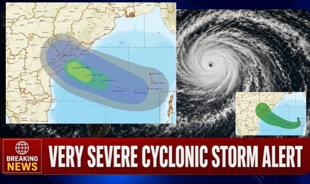
The India Meteorological Department (IMD) has issued a Pre-Cyclone Watch (Yellow Message) for the Andhra Pradesh and adjoining South Odisha coasts as a depression over the Eastcentral and adjoining Southeast Bay of Bengal is forecast to intensify rapidly and make landfall as a very severe cyclonic storm.
As of 1730 hours IST today, the system was centered near latitude 15.8°N and longitude 90.7°E, approximately 510 km north-northwest of Sri Vijaya Puram (Andaman Islands), 820 km east-southeast of Visakhapatnam, 910 km east-southeast of Kakinada, 1020 km east of Machilipatnam, and 1100 km east of Bapatla.
According to the Special Bulletin issued by the Meteorological Centre Bhubaneswar, the depression is very likely to move nearly southwards, intensify into a deep depression, and then gradually recurve west-northwestwards on 25 October. It is expected to strengthen into a cyclonic storm over the Eastcentral and adjoining Westcentral Bay of Bengal by the morning of 26 October and further into a severe cyclonic storm by the morning of 27 October.
Thereafter, the system is forecast to move northwestwards, intensify into a very severe cyclonic storm, and reach the Westcentral Bay of Bengal near the Andhra Pradesh coast around the morning of 28 October. It is very likely to cross the Andhra Pradesh and Yanam coasts between Bapatla and Visakhapatnam as a very severe cyclonic storm with maximum sustained wind speeds of 115-125 kmph, gusting to 140 kmph, by the forenoon of 28 October.
Rainfall and Wind Warnings for Odisha
While the primary landfall is expected over Andhra Pradesh, Odisha is set to experience significant weather impacts. Light to moderate rain or thundershowers are likely at many places on Day 4 (27-28 October) and at most places on Days 5 and 6.
Orange warnings (Be Prepared to Take Action) for heavy to very heavy rainfall have been issued for districts including Jagatsinghapur, Puri, Rayagada, Koraput, Malkangiri, Gajapati, and Ganjam. On Day 5, red warnings (Take Action) cover heavy to very heavy rainfall at a few places with extremely heavy rainfall at isolated places over Rayagada, Koraput, Malkangiri, Gajapati, and Ganjam. Thunderstorms with lightning and gusty winds of 40-70 kmph are also expected in several southern and coastal districts.
Sea Conditions and Safety Advisories
Squally weather and gale-force winds are expected over large parts of the Bay of Bengal in the coming days, with phenomenal sea conditions near the Andhra Pradesh coast around the time of landfall. Fishermen have been strongly advised not to venture into the Eastcentral and adjoining Southeast Bay of Bengal and along & off Andaman Islands till 26 October, Westcentral and adjoining Northwest & Southwest Bay of Bengal from 26 to 28 October, and along & off Andhra Pradesh-Odisha coasts from 27 to 28 October.
Distant Cautionary Signal No-I (DC-1) has been advised to be hoisted at all ports of Odisha.
Impacts and Preparedness
The IMD has warned of possible damage to plantations, horticulture, standing crops, kutcha houses, power and communication lines, and embankments. Localized flooding, waterlogging, disruption of traffic, and risk of landslides or mudslides in vulnerable areas are also anticipated.
Residents are advised to stay indoors, secure loose objects, unplug electrical appliances, avoid coastal areas and low-lying regions, and closely monitor official updates.
The situation is being closely monitored, with subsequent bulletins expected from the IMD.