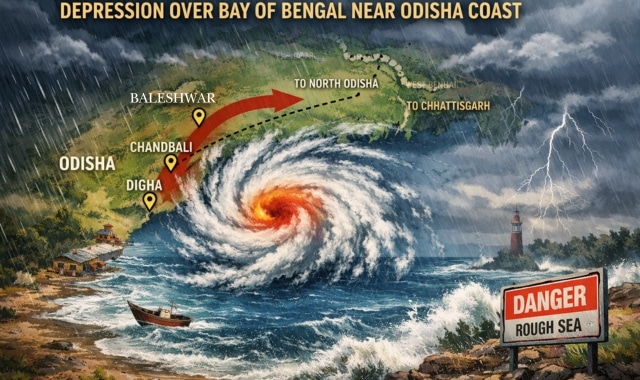
A depression formed over the northwest Bay of Bengal and adjoining North Odisha–West Bengal coasts early Sunday, intensifying from a well-marked low-pressure area.
The system lay centred near latitude 21.1°N and longitude 87.2°E, about 50 km south-southeast of Balasore, 60 km northeast of Chandbali, and 60 km south-southwest of Digha.
The India Meteorological Department (IMD) reported that the depression will move west-northwestward and cross the North Odisha coast between Chandbali and Digha close to Baleshwar within 24 hours. It will continue toward North Odisha and North Chhattisgarh during the next day.
Heavy rainfall lashed several parts of Odisha, with Khajuripada in Kandhamal recording 28 cm, Tureikela in Bolangir 26 cm, and Phulbani 22 cm. Other areas including Baliguda, Titlagarh, and Nischintakoili also received significant rainfall.
IMD warned of rough to very rough sea conditions along and off the Odisha coast from July 5 to 7. Fishermen have been advised not to venture into the sea during this period. Ports across Odisha have hoisted Local Cautionary Signal No-III.
Authorities cautioned about localised flooding, waterlogging, and traffic disruptions in urban areas. The department also highlighted risks of landslides, crop damage, and minor structural losses in vulnerable regions.
Residents have been urged to avoid low-lying areas and follow official advisories. The system is expected to bring widespread rainfall before weakening gradually as it moves inland.


