A weather system that was still a Depression this morning has now packed more punch.
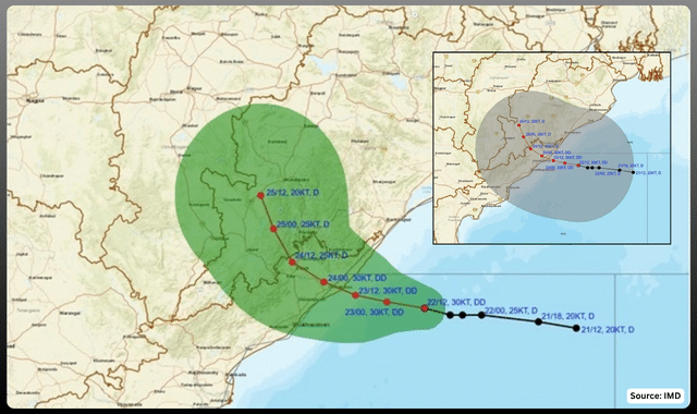
As of 5.30 PM on Tuesday, the Depression over the west-central and adjoining northwest Bay of Bengal intensified into a Deep Depression. It lay centred near latitude 18.0°N and longitude 85.4°E — about 140 km east-southeast of Kalingapatnam in Andhra Pradesh, 150 km south-southeast of Gopalpur in Odisha, 210 km south-southwest of Puri, and 220 km east of Visakhapatnam.
It moved west-northwestwards at 7 kmph during the previous six hours. That slower, more organised motion is typical as a system consolidates.
IMD’s forecast is clear: the Deep Depression will continue west-northwestwards and is very likely to cross the north Andhra Pradesh–south Odisha coasts between Visakhapatnam and Gopalpur as a Deep Depression by the night of 23 September.
That puts landfall roughly 24 hours away.
What this means on the ground
A Deep Depression is one step below a cyclonic storm. It is not yet “Cyclone Arnab” — the next name on the regional list, contributed by Bangladesh — but it is strong enough to deliver serious weather. Media speculation about a named cyclone is running ahead of the official classification.
Expected impacts:
– Heavy to very heavy rainfall, with isolated extremely heavy falls, over parts of coastal and south Odisha and north coastal Andhra Pradesh.
– Squally winds, already in the 45–55 kmph range and likely to rise to 55–65 kmph gusting 75 kmph over the west-central and adjoining northwest Bay.
– Rough to very rough seas, occasionally high, with poor visibility in heavy rain.
– Risk of waterlogging, localised flooding in low-lying areas, and disruption to road and ferry traffic.
Odisha has already closed schools and anganwadis in several districts, cancelled leave for government staff in vulnerable areas, and restricted some ghat roads and Chilika ferry services. Red and orange alerts are in force for districts including Srikakulam, Vizianagaram, Ganjam, Gajapati and neighbouring inland areas.
Fishermen have been advised not to venture into the sea along and off the Andhra, Odisha and West Bengal coasts until at least 25 September.
Why the timing matters
The system is arriving as the southwest monsoon continues to withdraw from northwest India. That contrast — a late-season Bay system still drawing moisture while the monsoon retreats over land — often produces disproportionately heavy rain even from a Deep Depression that never quite becomes a cyclone.
Satellite imagery around 1730 IST showed a well-marked vortex near 18.0°N, 85.5°E with intense convection wrapped around it. The centre has edged closer to the coast through the day.
Authorities in Visakhapatnam, Srikakulam, Ganjam and Gajapati are watching river levels and low-lying settlements. Residents in coastal and adjoining districts should stay updated through official IMD and state disaster-management channels, avoid unnecessary travel near the coast, and keep emergency kits ready.
The next 24–36 hours will decide how much rain actually falls and how the system weakens after landfall. For now, the message from the weather office is straightforward: the Deep Depression is real, it is closer, and Wednesday night is the window to watch.