The Bay system now has a number, a track and a colour-coded warning chart. Late on Monday, Meteorological Centre Bhubaneswar issued **Special Bulletin-1 (BoB/06/2026)** at **2200 hrs IST**, confirming that the well-marked low over the Bay of Bengal has become a **Depression** and is pointed at the north Andhra Pradesh–south Odisha coast.
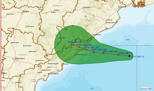
At **1730 hrs IST on 21 September 2026**, the Depression lay over the west-central and adjoining northwest Bay near **17.7°N, 87.8°E** — about **310 km southeast of Puri**, **310 km east-southeast of Gopalpur**, **390 km east-southeast of Kalingapatnam** and **470 km east of Visakhapatnam**. Maximum sustained winds were **45–55 kmph, gusting to 65 kmph**.
IMD says it will keep moving **west-northwest**, deepen into a **Deep Depression** during the next 24 hours, and **cross between Visakhapatnam and Gopalpur as a Deep Depression during the night of 23 September to the early hours of 24 September**.
This is still not a cyclonic storm. The official forecast keeps it in the Depression–Deep Depression range, then weakens it again after landfall. The rain threat, not a hurricane-force core, is the main story for Odisha.
Peak intensity in the bulletin is **55–65 kmph, gusting to 75 kmph**, around the time the centre is nearest the coast. After crossing, the system is forecast to drift inland and weaken.
Rain so far has been modest. Accumulated totals ending 1730 IST on 21 September included **Paradeep 23.6 mm**, **Chandbali 18 mm**, **Cuttack 13.6 mm**, **Kendrapara 12 mm**, **Puri 11.2 mm** and **Chatrapur 10 mm**. The heavier burst is still ahead.
When the colours turn red
**Day 1 (till 8.30 am, 22 Sept)**
Orange: isolated heavy to very heavy rain over **Gajapati and Ganjam**.
Yellow: isolated heavy rain over Baleshwar, Bhadrak, Jajpur, Kendrapara, Jagatsinghpur, Cuttack, Dhenkanal, Keonjhar, Mayurbhanj, Puri, Khordha and Nayagarh.
**Day 2 (22–23 Sept)**
Orange spreads across the coast and south interior: Baleshwar, Kendrapara, Jagatsinghpur, Cuttack, Mayurbhanj, Rayagada, Koraput, Malkangiri, Gajapati, Ganjam, Puri, Khordha and Nayagarh.
**Day 3 (23–24 Sept) — landfall window**
**Red — take action:** heavy to very heavy rain at a few places, with **isolated extremely heavy rain**, over **Koraput, Gajapati and Ganjam**.
Orange: Jagatsinghpur, Cuttack, Kalahandi, Kandhamal, Nabarangpur, Rayagada, Malkangiri, Puri, Khordha, Nayagarh.
**Day 4 (24–25 Sept)**
**Red:** isolated extremely heavy rain over **Kalahandi, Nabarangpur, Koraput and Malkangiri**.
Orange: Nuapada, Balangir, Kalahandi, Rayagada, Gajapati, Ganjam.
Warnings then ease to Orange over western districts on Day 5 and Yellow by Day 6. The pattern is familiar for a Bay system coming ashore on the Ganjam–Srikakulam belt: a sharp hit on the south coastal and south interior districts, then a rain shield sliding west into the Kalahandi–Koraput–Malkangiri tract.
Sea, ports, fishermen
Squally winds of **45–55 kmph, gusting 65 kmph**, already cover parts of the east-central and northeast Bay. They rise to **50–60 gusting 70** over the central Bay on 22 September, and to **55–65 gusting 75** over the west-central and northwest Bay on 23 September, lasting into the evening of the 24th.
Along and off the **south Odisha–north Andhra Pradesh coasts**, squally weather of **40–50 gusting 60 kmph** is likely from Tuesday morning, increasing to **55–65 gusting 75 kmph** from early Wednesday through Thursday evening.
Seas will be **rough to very rough** over the west-central Bay from today through 24 September, and along the north Andhra–Odisha–West Bengal coasts from Tuesday evening through Thursday evening.
IMD’s instruction:
- Do not venture into the east-central and adjoining northeast Bay from **today until 22 September**.
- Stay out of the west-central, northwest and southwest Bay, and waters along the Andhra–Odisha–West Bengal coasts, from **22 to 24 September**.
- **Fishermen should return to the coast by this evening, 21 September.**
**Local Cautionary Signal No. III (LC-3)** has been hoisted at **all ports of Odisha**.
What it can do on land
The bulletin’s impact list is the practical one: damage to plantations, banana and papaya; flying loose objects; snapped branches and some uprooted trees; waterlogging and closed underpasses in towns; poor visibility; local landslips in the ghats; disruption to small boats, trawlers, road and rail, and helicopter sorties.
Advice matches the colour code. Stay indoors if the rain turns extreme. Avoid trees, waterbodies and kutcha structures. Unplug appliances. Keep off flood-prone roads. Tourism, fishing and offshore work should be regulated until the system weakens.
The centre of the Depression is still more than 300 km from Gopalpur. Tracks can shift inside the cone of uncertainty. But the official envelope is now tight enough for Ganjam, Gajapati, Koraput and the adjoining Andhra coast to treat **Wednesday night and Thursday** as the critical period.
Updates will come with every six-hour bulletin. Until then, the safest forecast is the one already on the wall at Meteorological Centre Bhubaneswar: a Deep Depression, a short crossing window, and isolated extremely heavy rain where the hills meet the sea.