
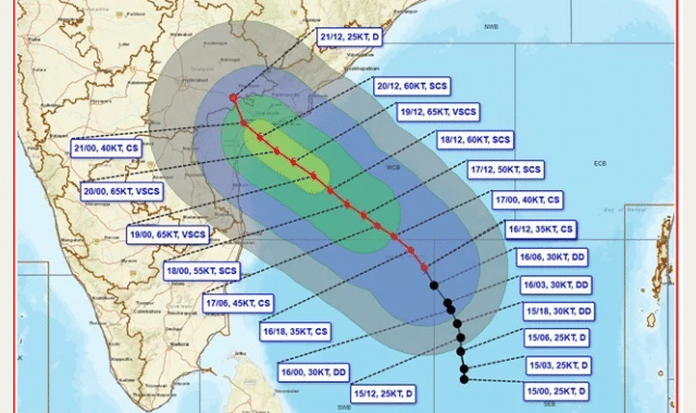
A deep depression over the Bay of Bengal intensified into Cyclonic Storm ‘Akvan’ (pronounced Ak-van) on Monday evening, prompting the India Meteorological Department (IMD) to issue an Orange Message (Cyclone Alert) for the coasts of Andhra Pradesh and adjoining South Odisha.
According to the IMD’s 5:30 PM bulletin on Nov 16, the system moved north-northwestwards at a speed of 10 kmph over the preceding six hours. It currently lies centred over the central parts of the South and adjoining Westcentral Bay of Bengal near Latitude 12.2°N and Longitude 85.7°E.
Current Distance from Key Coastal Points:
- 610 km east of Chennai (Tamil Nadu)
- 630 km northeast of Trincomalee (Sri Lanka)
- 660 km southeast of Machilipatnam (Andhra Pradesh)
- 670 km south-southeast of Visakhapatnam (Andhra Pradesh)
- 790 km south of Gopalpur (Odisha)
Intensification and Landfall Forecast
Meteorological models indicate that Cyclone Akvan will continue moving north-northwestwards and rapidly gather strength over warm sea waters. The IMD projects the following timeline:
- Nov 17 (Evening): Expected to intensify into a Severe Cyclonic Storm over the westcentral Bay of Bengal.
- Nov 19 (Morning): Projected to turn northwestwards and further escalate into a Very Severe Cyclonic Storm.
- Nov20 (Around Noon): Forecasted to cross the Andhra Pradesh and Yanam coasts between Nellore and Tuni as a Very Severe Cyclonic Storm.
At the time of landfall, Cyclone Akvan is expected to pack maximum sustained wind speeds of 120–130 kmph, gusting up to 145 kmph.
Disaster management authorities in Andhra Pradesh, Yanam, and southern Odisha have been placed on high alert as coastal districts prepare for squally winds, heavy rainfall, and rough sea conditions over the coming days. Fishermen have been strictly advised not to venture into the deep sea.