
Barely recovering from the impacts of Cyclone Arnab, residents of South Odisha are bracing for another major storm as Cyclone ‘Murasu’ intensifies rapidly over the Bay of Bengal.
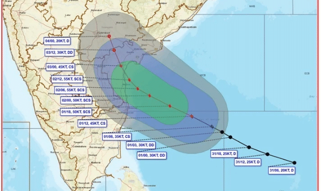
According to the latest bulletin from the India Meteorological Department (IMD), the system is currently moving west-northwestwards at a speed of 27 km/h over the southwest and adjoining west-central Bay of Bengal.
As of 2:30 PM, the storm was centered approximately 480 km east-southeast of Chennai, 550 km from Nellore, 560 km from Machilipatnam, 600 km from Ongole, and 610 km from Visakhapatnam.
Landfall and Wind Speeds
IMD forecasts indicate that Cyclone Murasu will intensify into a Severe Cyclonic Storm over the west-central Bay of Bengal by the morning of November 2. Continuing its northwest trajectory, the system is expected to cross the South Andhra Pradesh coast between Nellore and Narasapur between 11:30 PM on November 2 and 4:00 AM on November 3.
During landfall, sustained wind speeds are projected to reach 100 to 110 km/h, with gusts reaching up to 120 km/h. Cyclone warnings have been issued along the coasts of Andhra Pradesh and northern Tamil Nadu, with fishermen strictly advised to stay out of the sea.
Impact on South Odisha: Orange and Yellow Warnings Issued
While the primary landfall will occur in Andhra Pradesh, South Odisha is set to experience intense rainfall and strong squalls:
- November 2: Light to moderate rain or thunderstorms are likely across most districts, including Sonpur, Boudh, Nuapada, Balangir, Kalahandi, Kandhamal, Nabarangpur, Rayagada, Koraput, Malkangiri, Gajapati, Ganjam, Puri, Khordha, and Nayagada. A Yellow Warning has been issued for heavy rain in isolated parts of Gajapati and Ganjam, alongside lightning warnings and winds of 40–50 km/h for several southern and coastal districts.
- November 3 & 4: Conditions are set to deteriorate sharply. An Orange Warning for heavy to very heavy rainfall has been issued for Rayagada, Koraput, Malkangiri, Gajapati, and Ganjam, accompanied by wind speeds of 50–60 km/h. A Yellow Warning for heavy rain remains active for Kalahandi, Kandhamal, Nabarangpur, Puri, Khordha, and Nayagada.
- November 5: Rain intensity is expected to ease gradually, though a Yellow Warning will remain for scattered thunderstorms and squall-like conditions in select areas.
Advisory and Capital Outlook
Authorities have warned of potential low-lying waterlogging, flash flooding, reduced visibility, and traffic disruptions across affected districts. Citizens are strongly advised to avoid unnecessary travel, check traffic advisories, and follow instructions from local administration.
For the capital city of Bhubaneswar and surrounding areas, the regional weather center predicts a generally cloudy sky with a chance of rain or thunderstorms over the next 24 hours. Temperatures are expected to peak around 34°C during the day and drop to 24°C at night.