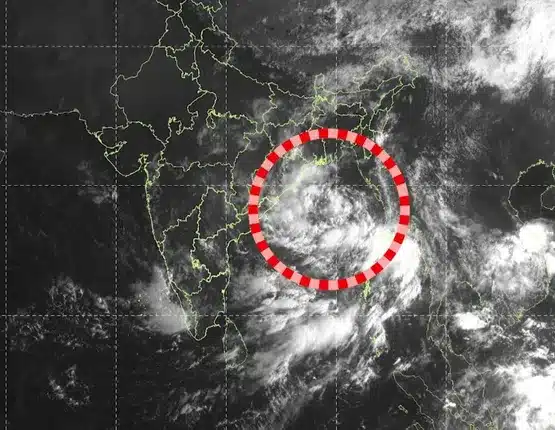
The Depression over the west-central and adjoining northwest Bay of Bengal is moving west-northwestwards and is likely to intensify into a Deep Depression within the next 12 hours, the India Meteorological Department (IMD) said on Tuesday.
The system is forecast to continue moving west-northwestwards and cross the North Andhra Pradesh-South Odisha coast between Visakhapatnam and Gopalpur during the night of September 23 and the early hours of September 24, 2026.
Depression located 220 km from Gopalpur, Puri
According to the IMD bulletin, the system moved west-northwestwards at around 17 kmph during the six hours preceding 5:30 am on September 22.
At 5:30 am, the Depression was centred near 17.9°N latitude and 86.3°E longitude. It was located approximately:
- 220 km southeast of Gopalpur
- 220 km south-southeast of Puri
- 230 km east-southeast of Kalingapatnam in Andhra Pradesh
- 320 km east of Visakhapatnam
The system is being continuously monitored by the IMD.
Deep Depression likely within 12 hours
The Depression is expected to intensify into a Deep Depression over the west-central and adjoining northwest Bay of Bengal during the next 12 hours.
The forecast track indicates that it will maintain its west-northwestward movement before approaching the coast between Visakhapatnam and Gopalpur.
The IMD had earlier forecast the system to intensify into a Deep Depression and cross the North Andhra Pradesh-South Odisha coast during the night of September 23 to the early hours of September 24.
Strong winds, rough sea conditions
The system is also expected to produce squally weather over parts of the Bay of Bengal.
Winds are forecast to reach 50-60 kmph, gusting to 70 kmph, over the central Bay of Bengal on September 22. These could strengthen to 55-65 kmph, gusting to 75 kmph, over the west-central and adjoining northwest Bay of Bengal on September 23 and continue until the evening of September 24.
Sea conditions are expected to remain rough to very rough over the west-central and adjoining northwest Bay and along and off the North Andhra Pradesh-Odisha coasts.
Fishermen have been advised not to venture into the sea, particularly as the system approaches the coast.
Heavy rain likely over south Odisha
The Depression and its associated weather systems are expected to trigger heavy to very heavy rainfall over several parts of south Odisha and north coastal Andhra Pradesh.
Some areas could also receive extremely heavy rainfall, particularly during the peak impact period around September 23 and 24. The IMD has separately warned of isolated extremely heavy rainfall over south Odisha and north coastal Andhra Pradesh during this period.
Neighbouring areas of Chhattisgarh and Telangana may also receive significant rainfall under the influence of the system and associated troughs.
Odisha districts remain on alert
With the system expected to approach the coast, authorities in Odisha and Andhra Pradesh have stepped up preparedness measures.
Several districts in south Odisha are under rainfall and thunderstorm warnings, with coastal areas also being monitored for strong winds, rough seas, localised flooding and waterlogging in low-lying areas.
Residents in coastal and adjoining districts have been advised to remain vigilant and follow updates issued by the IMD and state disaster management authorities.
People are also advised to avoid unnecessary travel to coastal and low-lying areas during the period of peak impact.
Fishermen advised to stay away from sea
The IMD has advised fishermen not to venture into the affected areas as sea conditions are expected to deteriorate further.
Fishing operations are recommended to remain suspended in areas experiencing strong winds and rough to very rough seas.
The weather system will continue to be closely monitored as it moves towards the North Andhra Pradesh-South Odisha coast. Further updates and warnings are expected from the IMD as the system intensifies and approaches land.