
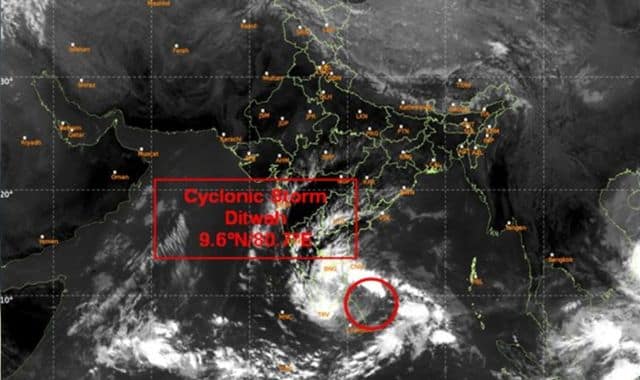
The cyclonic storm Ditwah, brewing over the northern adjacent areas of the southwest Bay of Bengal, has been steadily advancing, posing potential threats to coastal regions in southern India. In the past six hours, the storm moved at a speed of 10 km/h toward northern Sri Lanka and remained centered over that region on November 29. Currently, it is positioned approximately 250 km south-southeast of Puducherry (India) and 350 km south of Chennai (India).
According to the India Meteorological Department (IMD), Ditwah is expected to continue its north-northwest trajectory, approaching the coasts of northern Tamil Nadu, Puducherry, and adjacent southern Andhra Pradesh over the southwest Bay of Bengal by the morning of November 30. Forecasts indicate that between the night of November 29 and the dawn and evening of November 30, the storm will intensify and centre itself over the southwest Bay of Bengal, maintaining a minimum distance of 60 km, 50 km, and 25 km from the Tamil Nadu-Puducherry coastline.
The influence of this cyclonic system has brought noticeable changes to weather patterns in Odisha. The winter chill has diminished, with night temperatures rising across the state. Over the last 24 hours, mercury levels have climbed above 10 degrees Celsius everywhere. In Daringbadi and Phulbani, the minimum temperature recorded was 10 degrees Celsius. Additionally, a high-pressure area remains active in the atmosphere, contributing to these shifts.
This morning, Ditwah’s approach has led to foggy conditions along the coast, with dense fog reported in five districts today. Residents in affected areas are advised to stay updated on IMD alerts as the storm progresses.


