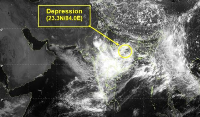
The India Meteorological Department (IMD) has issued a fresh weather advisory as a depression over north Chhattisgarh and adjoining Jharkhand continues to move westward, bringing significant rainfall across Odisha.
Centred near latitude 23.3°N and longitude 84.0°E, the system was reported to be 80 km south of Daltonganj (Jharkhand), 80 km east of Ambikapur (Chhattisgarh), and 320 km east of Umaria (Madhya Pradesh) at 0830 hrs IST today. It is expected to weaken into a well-marked low-pressure area by July 27.
The monsoon trough, extending across northern India and passing through Odisha, has fueled heavy showers, particularly in Mayurbhanj district. Key rainfall figures include Muruda (18 cm), Bahalda (17 cm), Baripada and Jamda (16 cm each), and Kusumi (13 cm).
In light of this, the IMD has issued an Orange Warning for Sundargarh, cautioning about heavy to very heavy rainfall, thunderstorms, and gusty winds up to 40 kmph. A Yellow Warning is in place for districts including Jharsuguda, Sambalpur, Keonjhar, Mayurbhanj, and Bargarh.
Fishermen have been strongly advised against venturing into the North Bay of Bengal, with sea conditions predicted to be rough to very rough through July 29.
The weather system is expected to bring light to moderate rainfall across coastal and interior Odisha over the next five days, with declining intensity after July 28.


