

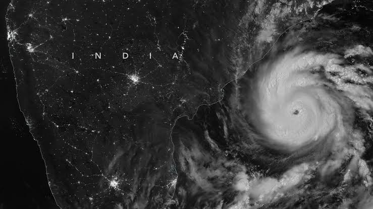
The India Meteorological Department (IMD) has issued a fresh high alert as Cyclonic Storm Murasu over the westcentral Bay of Bengal intensified into a severe cyclonic storm on Monday morning, November 2, 2026.
Moving west-northwestwards at a speed of 22 kmph, the storm system lay centered at 08:30 IST over the Westcentral Bay of Bengal. As per IMD coordinates, the severe cyclone was located approximately 160 km east-southeast of Nellore, 180 km northeast of Chennai, 180 km east-southeast of Kavali, 210 km southeast of Ongole, and 240 km south of Machilipatnam.
Landfall Window and Wind Speed
The IMD updated that Cyclone Murasu is very likely to move northwestwards and cross the south Andhra Pradesh coast between midnight tonight (November 2) and the early hours of Tuesday, November 3, 2026.
- Landfall Zone: The core impact area is projected between Nellore and Narsapur, passing close to the south of Ongole.
- Wind Intensity: During landfall, sustained surface wind speeds of 100 to 110 kmph, gusting up to 120 kmph, are expected to lash coastal districts.
- Storm Surge Warning: Coastal inundation of 1.0 to 1.5 meters above the astronomical tide is anticipated across low-lying areas of Bapatla, Prakasam, Guntur, and Krishna districts.
District Alerts, Safety Measures, and Evacuations
State disaster management authorities across Andhra Pradesh and neighboring Tamil Nadu have stepped up emergency preparedness:
- Red Alerts: The IMD has placed Nellore, Prakasam, Bapatla, Guntur, and Krishna under Red Alert for extremely heavy rainfall and squally winds.
- Fishermen Advisory: Complete suspension of all sea operations has been ordered along and off the Andhra Pradesh, North Tamil Nadu, and South Odisha coasts through November 4.
- Disaster Response: Teams from the National Disaster Response Force (NDRF) and State Disaster Response Forces (SDRF) have been deployed across vulnerable coastal belts to facilitate preemptive evacuations and tree-clearing operations.