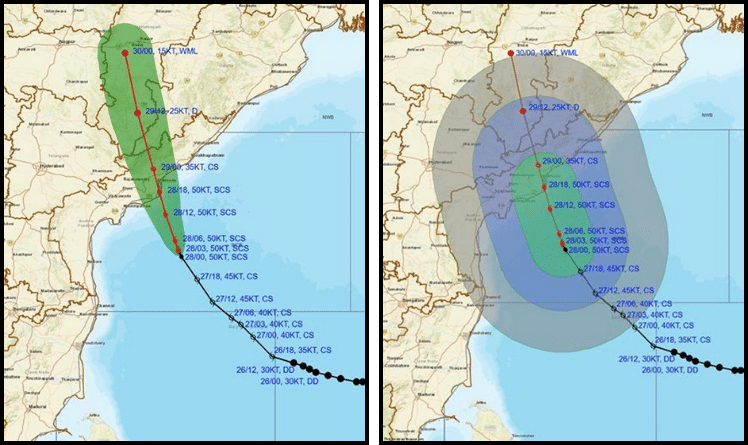
The India Meteorological Department (IMD) has issued a severe cyclone warning for southern Odisha as Cyclone Montha gains strength over the west-central Bay of Bengal.
At 8:30 a.m. on October 28, the storm was located 160 km south-southeast of Machilipatnam and 530 km from Gopalpur, Odisha. It continues to move north-northwest at 12 kmph and is expected to make landfall between Machilipatnam and Kalingapatnam near Kakinada by tonight.
Packing sustained winds of 90–100 kmph and gusts up to 110 kmph, Montha poses a serious threat to coastal and interior regions. IMD forecasts show the cyclone will gradually weaken after landfall, transitioning into a depression by the evening of October 29.
Meanwhile, rainfall has intensified across southern Odisha. Ganjam and Gajapati districts recorded up to 12 cm of rain in the past 24 hours. IMD issued orange and yellow alerts for several districts, predicting extremely heavy rainfall—over 20 cm—in Malkangiri, Koraput, Rayagada, Gajapati, and Ganjam. Kalahandi, Kandhamal, Nayagarh, Khurda, and Puri are also likely to receive heavy to very heavy showers.
Wind warnings remain in effect for both land and sea. Gale-force winds of 60–80 kmph are expected along and off the Odisha coast through October 29. Sea conditions are high to very high, prompting a ban on fishing until October 30. Ports such as Gopalpur, Paradip, Dhamra, Puri, Chhatrapur, and Chandbali have hoisted cautionary signals.
IMD warns of damage to thatched houses, power lines, roads, and crops. Localized flooding, landslides, and traffic disruptions are likely. Authorities urge residents to stay indoors, avoid coastal zones, and monitor official updates.


