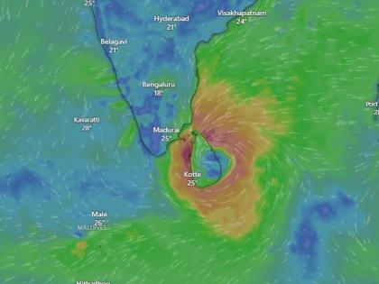
Cyclonic Storm Ditwah is steadily advancing toward the north Tamil Nadu, Puducherry, and south Andhra Pradesh coastlines, the India Meteorological Department (IMD) confirmed on Friday.
The system, positioned over coastal Sri Lanka and the adjoining southwest Bay of Bengal, was last observed about 480 km south–southeast of Puducherry and 580 km south–southeast of Chennai late Thursday night.
Storm Path and Current Intensity
IMD reports indicate that Cyclone Ditwah is moving northwest at nearly 8 kmph. The storm is expected to cross the Sri Lankan coast before tracking into the Bay of Bengal and moving toward the north Tamil Nadu, Puducherry, and south Andhra Pradesh coasts by November 30.
While the system is not expected to intensify into a severe cyclonic storm, strong winds and heavy rainfall are forecast along the affected coastal regions.
-
Wind speeds near the storm’s centre may reach 60–80 kmph, gusting to 90 kmph.
-
Outer bands may record 35–55 kmph winds, which could disrupt marine and coastal activities.
Alerts and Preparedness Measures
The Regional Meteorological Centre (RMC), Chennai, has issued a red alert for the Cauvery Delta districts:
-
Thanjavur
-
Tiruvarur
-
Nagapattinam
-
Mayiladuthurai
An orange alert is in effect for:
-
Chennai
-
Tiruvallur
-
Kancheepuram
-
Ranipet
-
Chengalpattu
Authorities have urged fishermen to completely avoid the south, central, southwest, and southeast Bay of Bengal for the next five days due to hazardous sea conditions.
Heavy Rain Forecast for Andhra Pradesh
The Andhra Pradesh State Disaster Management Authority (APSDMA) has warned of heavy to very heavy rainfall across South Coastal Andhra Pradesh and Rayalaseema beginning Saturday. Districts likely to experience intense rain include:
-
Chittoor
-
Tirupati
-
Nellore
-
Prakasam
-
YSR Kadapa
State officials have initiated preparedness operations as the region braces for potential flooding, strong winds, and travel disruptions.


