
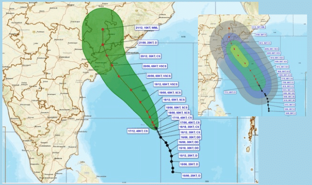
Cyclone Akvan, churning over the central and west-central Bay of Bengal, has intensified into a severe cyclonic storm and slightly altered its trajectory due to atmospheric pressure changes, putting both Andhra Pradesh and southern Odisha on high alert.
According to the India Meteorological Department (IMD), the storm remained virtually stationary for several hours on Monday before beginning a slow northwestward movement. As of the latest tracking, Akvan is positioned roughly 590 km east of Chennai, 650 km southeast of Machilipatnam, 650 km south-southeast of Visakhapatnam, and about 780 km south of Gopalpur in Odisha.
Intensification and Landfall Forecast
Meteorologists warn that while the system has shifted its track slightly, its destructive potential remains unchanged. Gathering strength over warm ocean waters, Akvan is projected to escalate into a Very Severe Cyclonic Storm by the evening of November 19. Continuing northwest, it is expected to make landfall between Nellore and Visakhapatnam along the Andhra Pradesh and Yanam coasts around noon on November 20. At landfall, sustained wind speeds are forecast to reach 120–130 km/h, with violent gusts peaking at 145 km/h.
Marking the third cyclonic system to form in the Bay of Bengal in just three weeks, Akvan follows a string of recent storms that battered the Andhra coastline. An Orange Warning has been issued for the Andhra Pradesh and adjoining south Odisha coasts, and fishermen have been strictly advised not to venture into the sea until November 21.
Odisha Braces for Outer-Band Fury
Although Cyclone Akvan will bypass a direct landfall in Odisha, its expansive outer cloud bands will trigger widespread adverse weather across the state before the system weakens into a depression by the night of November 21. Southern districts—including Ganjam, Gajapati, Puri, Rayagada, Koraput, Malkangiri, and Nabarangpur—will bear the brunt of the storm’s peripheral impact.
The Regional Meteorological Centre has issued a phased warning schedule for Odisha:
- November 17–18: Light to moderate rain and thundershowers are likely in Balasore, Bhadrak, Jajpur, Kendrapara, Jagatsinghpur, Cuttack, Mayurbhanj, Gajapati, Ganjam, Puri, Khordha, and Nayagarh.
- November 18–19 (Yellow Warning): Heavy rainfall is expected at isolated places in Gajapati, Ganjam, and Puri. Thunderstorms accompanied by lightning and gusty winds reaching 40–50 km/h are forecast across 15 coastal, northern, and southern districts.
- November 19–20 (Orange Warning): Weather conditions will deteriorate sharply across the state. Heavy to extremely heavy rainfall is likely in Kendrapara, Jagatsinghpur, Gajapati, Ganjam, and Puri. Heavy rain will also lash interior and northern pockets including Angul, Dhenkanal, Keonjhar, and Mayurbhanj, accompanied by squally winds of 50–60 km/h.
- November 20–21 (Orange Warning): Intense downpours will shift toward southern and western Odisha, with extremely heavy rainfall warnings in place for Rayagada, Koraput, Malkangiri, Gajapati, and Ganjam. Heavy rain is also predicted for Sambalpur, Subarnapur, Balangir, and Kalahandi.
Post-Landfall Outlook & Advisory
Widespread rain will persist through November 22 before tapering off to isolated light-to-moderate showers on November 23 and 24, with no weather warnings issued for those days.
In light of the approaching squalls and heavy downpours, authorities have cautioned that standing crops, horticultural plantations, and trees face a high risk of damage, alongside potential disruptions to power lines and communication networks caused by falling branches.