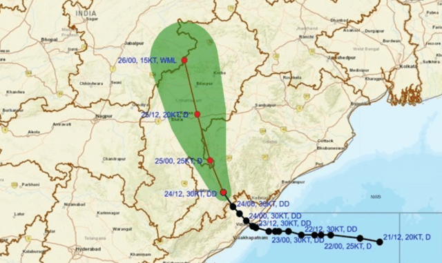
The Deep Depression that crossed the north Andhra–south Odisha coast late Wednesday remains over land and is still packing a punch.
The India Meteorological Department’s Meteorological Centre, Bhubaneswar, in its Special Bulletin-9 issued at 9 PM today, said the system lay centred at 1730 hrs IST near 19.1°N and 83.0°E — about 40 km northeast of Koraput, 60 km northwest of Parvatipuram (Andhra Pradesh) and 90 km south-southwest of Bhawanipatna.
It has been moving northwestwards at about 10 kmph. IMD expects it to continue north-northwestwards and weaken into a Depression in the next six hours, then keep weakening into a well-marked low by early 26 September. Doppler radars at Visakhapatnam, Raipur and Sambalpur are tracking it continuously.
Satellite imagery continues to show organised convection over the region.
Rain already recorded (ending 5:30 PM, 24 Sept): Koraput 10 cm, Malkangiri 9 cm, Nabarangpur 7 cm, Daringbadi 6 cm, Bhawanipatna 5 cm.
Rainfall Warnings (IMD Bhubaneswar)
Day 1 (valid till 0830 IST, 25 Sept) — TAKE ACTION**
- Red: Heavy to very heavy rain at a few places with extremely heavy rain at one or two places over Nabarangpur, Kalahandi and Koraput.
- Orange: Heavy to very heavy rain at one or two places over Nuapada, Balangir, Rayagada, Malkangiri, Kandhamal, Gajapati and Ganjam.
- Yellow: Heavy rain at isolated places over a long list of other districts including Bargarh, Balasore, Bhadrak, Kendrapara, Cuttack, Puri, Khordha and Mayurbhanj.
Day 2 (25–26 Sept): Orange warning only for Nuapada (heavy to very heavy). Yellow for several southern and western districts.
Day 3 (26–27 Sept): Isolated heavy rain possible over Bargarh and Nuapada (Yellow).
Light to moderate rain or thundershowers are expected at most places across Odisha for the next two days, becoming more scattered by Day 3.
Wind, sea and fishermen
Squally winds of 50–60 kmph gusting to 70 kmph are still occurring over coastal north Andhra, south Odisha and adjoining areas; they will ease to 45–55 kmph gusting 65 kmph from midnight and decrease thereafter. Very rough to rough sea conditions persist over the west-central and northwest Bay of Bengal and along the Odisha–north Andhra–West Bengal coasts until the morning of 25 September.
Fishermen have been advised **not to venture** into the west-central and adjoining northwest and southwest Bay of Bengal and along the Andhra–Odisha–West Bengal coasts till the morning of 25 September. Local Cautionary Signal No. III (LC-3) remains hoisted at all Odisha ports.
Flash-flood and impact warning
Low-to-moderate flash-flood risk exists over watersheds in Gajapati, Kalahandi, Koraput, Malkangiri, Rayagada, Nabarangpur, Khurda, Puri and several northern districts till 1730 IST on 25 September. Surface runoff and inundation are possible in already-saturated low-lying areas.
Expected impacts include waterlogging and traffic disruption in urban areas, localised landslides or mudslides in hilly terrain, damage to standing crops and banana/papaya plantations, uprooting of trees, minor damage to kutcha houses and power lines, and disruption of small-boat and helicopter operations.
What residents should do
Stay indoors, keep windows and doors closed, avoid travel if possible, and do not take shelter under trees. Unplug electrical appliances, stay away from water bodies and anything that conducts electricity. Check traffic conditions before heading out and follow official advisories. Tourism, recreational and onshore/offshore activities should be regulated.
The system is expected to lose intensity steadily as it moves further inland toward Chhattisgarh. However, the next 12–18 hours remain critical for south Odisha districts already under Red and Orange alerts. Keep following official updates from IMD Bhubaneswar and the Special Relief Commissioner.