Bhubaneswar: The India Meteorological Department (IMD) on Thursday informed that the well-marked Low-Pressure area over southwest and adjoining west-central Bay of Bengal off north Tamil Nadu-south Andhra Pradesh coasts has concentrated into a depression over southwest Bay of Bengal off north Tamil Nadu coast.
The system is very likely to move west-northwestwards and cross north Tamil Nadu and adjoining south Andhra Pradesh coasts around Chennai by the early morning of November 19, 2021.
As per IMD, light to moderate rain or thundershower is very likely to occur one or two places over the districts of Malkangiri, Koraput, Nabarangpur, Rayagada, Gajapati and Ganjam in the next 24 hours.
Weather forecast and warning for districts of Odisha for next five days:
Day-1 (valid up to 0830 hrs IST of 19.11.2021) Light to moderate rain or thundershower is very likely to occur at one or two places over the districts of Malkangiri, Koraput, Nabarangpur, Rayagada, Gajapati and Ganjam.
Day-2 (valid from 0830 hrs IST of 19.11.2021up to 0830 hrs IST of 20.11.2021) Light to moderate rain or thundershower is likely to occur at a few places over the districts of Malkangiri, Koraput, Rayagada and Gajapati.
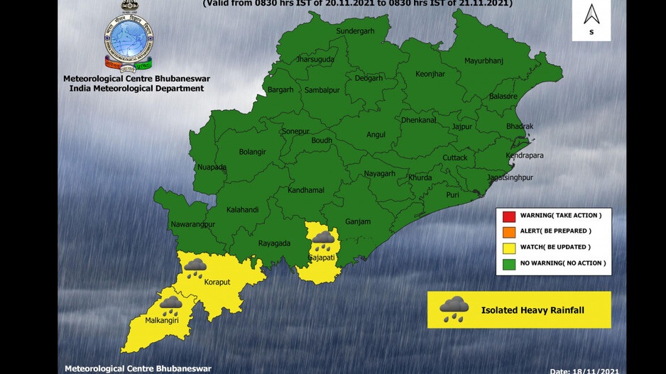
Day-3 (valid from 0830 hrs IST of 20.11.2021 up to 0830 hrs IST of 21.11.2021)
Yellow Warning (Be updated): Heavy rainfall is very likely to occur at one or two places over the districts of Malkangiri, Koraput and Gajapati.
Day-4 (valid from 0830 hrs IST of 21.11.2021 up to 0830 hrs IST of 22.11.2021) Light to moderate rain or thundershower is very likely to occur at a few places over the districts of Odisha.
Comments are closed.